Regrid Property App
- 4.85K
- 4.7
- Installs
- 500.00K
- Price
- Free

Screenshots
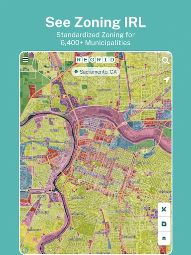
Analysis by Reviewed APKs
Regrid Property App turns a map into a way to look up parcel boundaries and property details across the United States. I found its appeal easiest to understand when I wanted to check who owns a piece of land or get a better sense of a lot before visiting. It suits curious property researchers and people working with land; it is a focused lookup tool, not a rental-management app.
A quick parcel check
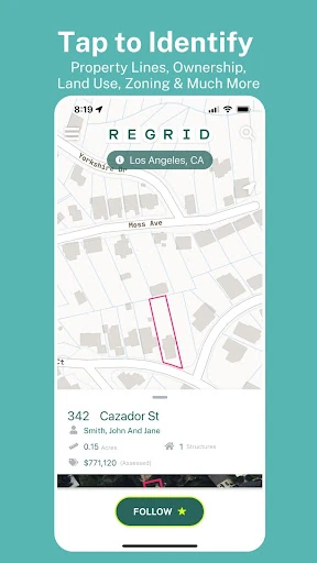
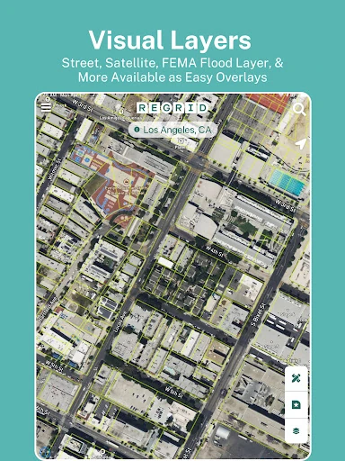
Imagine planning a drive past a vacant-looking lot and wanting to know where its boundaries fall. In Regrid, I can search for an address or place, switch between street and satellite views, and tap a parcel on the map. That gives the outing a practical starting point: I can inspect the mapped property information before deciding whether it is worth a closer look.
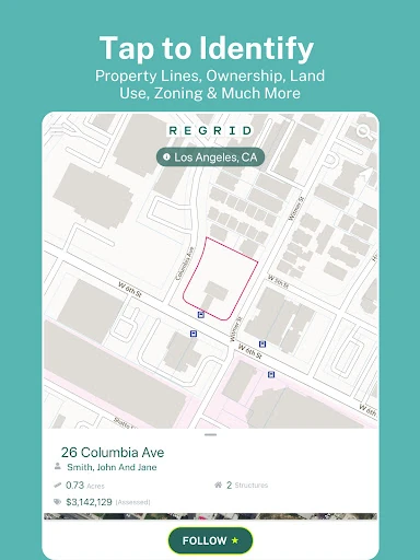
The details can include the parcel ID, address, owner, acreage, square footage, land use, and sale information. What I like about this approach is that the map stays central: I am not starting with a general real estate search and sorting through listings. I am looking at land itself, then opening the available public-record details for the parcel that caught my eye.
A map, not a listing service
Compared with a typical home-search app, Regrid is aimed more at parcel research than browsing homes for sale. Its map helps answer questions about property boundaries and recorded details, including ownership information where available. I can see it being useful for a landowner, real estate professional, or anyone trying to understand what sits around a location.
That focus also defines what it is not for. The app is not described as a place to list rentals, screen tenants, collect rent, or message residents. Nor should a map view replace checking details through the appropriate records when a decision depends on them. Regrid is a convenient way to explore property information, not a full transaction or property-management workflow.
Make research repeatable
For occasional lookups, the free experience offers nationwide parcel boundaries and details, with an email address required to access them. I would start by searching a familiar address, then try a nearby place and compare the street and satellite basemaps. That small practice makes it easier to recognize how parcels line up with roads and visible features when I am exploring somewhere new.
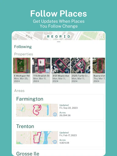
If I were following the same properties over time, the Pro Follow feature could make a more deliberate routine: save properties to a list and receive automated updates when things change. Pro also adds mapping layers and measurement tools. Those extras make more sense for recurring research than for a one-off question, so I would first see how often the free map answers what I need.
More From Our News Desk

Zoom Meetings, Google Meet, or Teams: Which Is Easiest to Join?

How I Build a Free Streaming Lineup With Tubi

Why Crunchyroll Is the Default Anime App for So Many Fans

YouTube TV: A Practical Guide to Cutting Cable

Rummikub and the Small Comfort of Phone Games
TeamViewer Remote Control or AnyDesk for Helping Family?
Who will find it useful
I would recommend Regrid to people who regularly need a map-based view of land: property owners checking parcel lines, real estate researchers comparing locations, or outdoor users curious about who owns nearby land. The ability to search by address or place and tap into parcel information keeps the basic task approachable, even if the details themselves are more specialized than a standard navigation app.
It may be less satisfying if you want a broad home marketplace, rental tools, or a map that answers every question about a property with certainty. Some features and data fields sit behind Pro, and property information can call for additional checking when precision matters. For casual curiosity, the free access is a sensible place to begin; frequent research makes the paid extras easier to evaluate.
Regrid Property App is developed by Regrid and is available on Google Play for Android 7.0 and later. It is free to install, has more than 500,000 installs, and holds a 4.7-star rating from 4,847 ratings. The content rating is Everyone. The app was released on March 6, 2018, and its current version is 1.84.0.
The app contains no ads, but it does offer in-app purchases, with listed items ranging from $9.99 to $100.00 each. The description also identifies a Pro plan at $10 per month, which adds features such as saved-property updates, extra map layers, measurement tools, and premium data fields. The free offering includes nationwide parcel access and basic map controls.
What It Feels Like to Explore Parcels
Opening the map
My first impression is that Regrid is organized around a clear action: find a location, then select a parcel. Instead of asking me to build a report or learn a complicated workflow upfront, it lets the map do most of the orienting. Searching by address or place gives me a straightforward route into the property information.
The free experience requires an email address for access to nationwide parcel details. Once in, the option to switch between street and satellite basemaps helps me approach the same place in different ways. I can use a familiar street view to get oriented, then satellite imagery to compare the mapped parcel with what appears on the ground.
Everyday map use
The core rhythm is simple: search, look over the map, tap a parcel, and read its available details. That is a useful sequence for a quick question during a drive-planning session or while comparing nearby lots at home. Regrid keeps boundaries and property records connected, so I do not have to treat the map and the parcel information as separate starting points.
The amount of information depends on the property and the data fields being viewed. Common details include parcel identification, address, ownership, acreage, square footage, and sale price and date. It is a practical collection for initial research, though I would treat it as a way to explore and orient myself rather than assume every field settles a question by itself.
More than boundaries
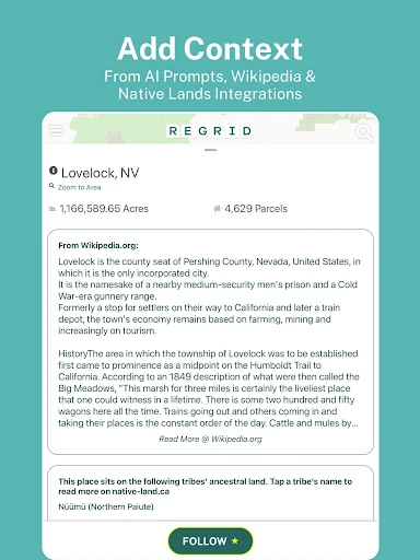
The standout idea is the breadth of property details attached to a map selection. Alongside boundaries and parcel IDs, the app can show ownership, mailing address, property value, land use, standardized zoning, and a vacancy indicator. Having those kinds of details in the same map-based workflow makes Regrid more useful than a simple line-on-a-map parcel viewer.
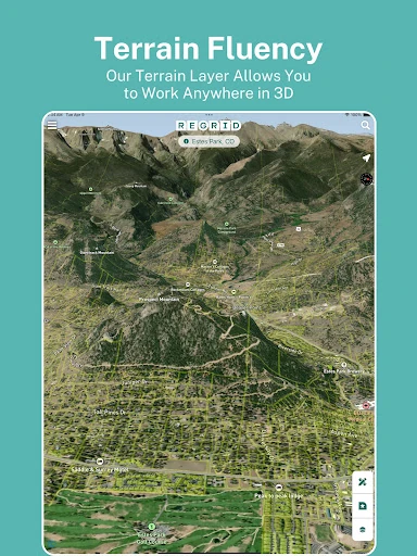
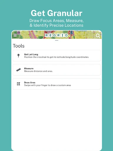
Pro extends that experience with a Follow feature for tracking properties and automated updates when things change. It also includes building-footprint and elevation contour layers, owner names and parcel IDs overlaid on the map, and tools for measuring linear feet, acreage, or square footage of a drawn area. Premium fields include vacancy, land use, building footprint data, and residential and vacancy indicators.
These additions are most compelling when I have a reason to revisit a location or measure a specific area. They are not necessary for every basic lookup, which is why the division between free access and Pro feels worth considering before subscribing.
A practical research routine
For a low-key weekend research session, I would pick a neighborhood or rural area and search for a place I already recognize. I can tap individual parcels, note the boundaries and details that matter, and share a link to a property of interest. That is handy when I want to bring someone else to the same parcel without trying to describe its position from memory.
For a project that spans several visits, Pro’s property list and Follow feature offer a more persistent approach. I could keep relevant parcels together, check automated updates, and use the additional layers or measurement tool when the question calls for them. The app’s tools are most useful when I know what I am trying to inspect, rather than browsing without a particular property question in mind.
Keep the scope in mind
Regrid is built around land and property information, so it will not replace a conventional navigation app for route planning or a property marketplace for browsing available homes. The description presents public-record parcel details and map layers, not a complete property transaction service. That distinction matters if I arrive expecting listings, rental applications, or communication between landlords and tenants.
There is also a practical split between the free map and the paid Pro tools. Free access covers parcel boundaries and details nationwide, plus search, basemap switching, and sharing; tracking, extra layers, measurement, and some data fields require Pro. If I only look up a property now and then, those paid features may be more than I need.
Finally, a tidy parcel outline can make research feel definitive when it is still only one useful source of information. I would use the app to orient myself and investigate, then seek further confirmation for questions where an exact boundary or record matters. That cautious habit suits a tool designed to make property data easier to explore.
Regrid Property App makes a specific job—exploring parcel boundaries and property details on a map—feel approachable. I like the direct search-and-tap workflow, the useful mix of property fields, and the fact that basic nationwide access is available without a time limit. Pro adds worthwhile tools for people who return to the same properties or need more map context.
I recommend trying the free version if you have a real reason to investigate land or property. It is less compelling as an all-purpose real estate app, and occasional users may not need Pro. For repeated parcel research, though, Regrid brings boundaries, records, and map layers together in a practical place.
Regrid Property App Frequently Asked Questions
What is Regrid Property App used for?
Regrid Property App is used to explore parcel boundaries and property information on a map. Search for an address or place, tap a parcel, and view available details such as its parcel ID, owner, acreage, land use, and sale information. It is geared toward property and land research rather than rental management or home listings.
Which devices can run Regrid Property App?
Regrid Property App is an Android app available through Google Play. It requires Android 7.0 or later. The app description also refers to additional mapping tools on the Regrid website, and Pro accounts use the same login for those tools. Check the store listing for current device compatibility and app requirements.
Does Regrid Property App cost anything?
The app is free to install and offers free access to nationwide parcel boundaries and details with an email address. It also has in-app purchases; listed items range from $9.99 to $100.00. The description gives a $10-per-month Pro plan with additional features. Check Google Play for current prices and plan details.
Does Regrid Property App have ads?
Google Play lists Regrid Property App as containing no ads. The app does offer in-app purchases for additional features. Its free map includes parcel access, searching, street and satellite basemap options, and sharing property links, while Pro adds tools and data fields. Plan details and availability may vary, so check the store listing.
Who should use Regrid Property App?
It may suit property owners, land researchers, real estate professionals, and outdoor users who want to look up parcel boundaries or ownership information. It is less suited to people seeking rental applications, rent collection, or a home-listing marketplace. The content rating is Everyone; whether its research tools fit your needs depends on how often you investigate properties.
Pros
- Search and inspect property parcels through a map-based workflow.
- Free access includes nationwide parcel boundaries and property details.
- Street and satellite basemaps offer different ways to view an area.
- Pro adds property tracking, measurement, and additional map layers.
Cons
- Several useful layers, tools, and data fields require a Pro plan.
- It focuses on parcel research rather than listings or rental management.
- Property records are a starting point, not a substitute for further checking.
- Category
- Maps & Navigation
- Version
- 1.84.0