MarineTraffic - Ship Tracking
- 121.58K
- 4.8
- Installs
- 5.00M
- Price
- Free

Screenshots
Analysis by Reviewed APKs
MarineTraffic - Ship Tracking is a map-based app for following ships and yachts, checking port activity, and seeing maritime conditions. It suits curious coastal observers as well as people who keep an eye on particular vessels or routes. I like how it turns a broad, busy subject into something I can explore at my own pace, though coverage and some advanced tools deserve a little attention before you rely on them.
A closer look at the harbor
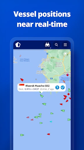
When I want to make sense of activity along the waterfront, MarineTraffic gives me a practical place to start. I can open the live map, look for vessels near me, and select ships or ports to explore. That makes a spare few minutes by the coast feel more informative: instead of guessing what is moving offshore, I can check the vessel positions the app displays and see what is happening around a port.
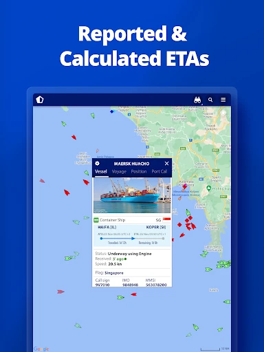
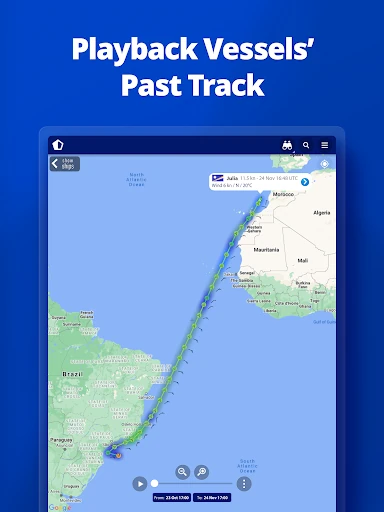
I also like having a way to look beyond the immediate map. Port arrivals and departures, estimated arrival times, and current port conditions add context to the dots on screen. If a vessel catches my eye, I can search for it and follow its track with animated playback. It is an easy routine for a curious observer: check what is nearby, pick out one ship, then spend a little time learning where it has been.
Tracking, not trip planning
The obvious alternatives are general-purpose map and weather apps, but MarineTraffic has a narrower focus. Its map is built around ships, yachts, ports, and AIS-reported positions, with wind information and port activity alongside them. I would choose it when I want to understand maritime movement rather than find a driving route or browse a broad map of local attractions.
That focus also sets expectations. MarineTraffic is not a tool for navigating a boat or making decisions that require complete, continuous vessel coverage. The app says its positions come through AIS receivers and notes that coverage varies by area; satellite tracking is available through an in-app purchase for vessels beyond land-based receiver range. I would treat the map as an informative view, not a substitute for situational awareness.
Small habits that help
A useful habit is to search for a vessel by name when I have a specific one in mind, then add it to My Fleet if I want an organized list. The fleet is shared across devices and MarineTraffic.com, which makes it more convenient than repeatedly starting from a fresh search. I can return to the vessels I care about and use the map or track playback to get a clearer sense of their movement.
For a casual check-in, I would pair the map with the wind forecast or the information for a nearby port. That gives me a little context without turning browsing into a project. The app also has a large photo collection covering ships, harbors, and lighthouses, so I can use it to explore visually when I do not have a particular vessel to follow. Checking local coverage first is sensible if one area is the main reason for installing it.
More From Our News Desk

Zoom Meetings, Google Meet, or Teams: Which Is Easiest to Join?

How I Build a Free Streaming Lineup With Tubi

Why Crunchyroll Is the Default Anime App for So Many Fans

YouTube TV: A Practical Guide to Cutting Cable

Rummikub and the Small Comfort of Phone Games
TeamViewer Remote Control or AnyDesk for Helping Family?
Who will enjoy it
I would recommend MarineTraffic to people who live near the water, watch ships as a hobby, or want a more informed view of port activity. It is also useful for anyone who regularly follows particular vessels and appreciates having a fleet list, track playback, and estimated arrival information in one place. The combination of a live map, wind forecasts, and port details gives curious users several ways to explore without needing a specific question every time.
It may be less satisfying if you expect complete coverage everywhere or need a navigation tool for operational decisions. The app’s own description points out that coverage depends on the area, and some satellite and advanced features are paid. People who only want general maps, or who rarely look at maritime activity, may find its specialist focus more than they need. I would check coverage for a particular region before paying for anything.
MarineTraffic - Ship Tracking is made by MarineTraffic Applications and is listed in Google Play under Maps & Navigation. It has more than 5 million installs and a 4.8-star rating from about 122,000 ratings. The app is free to download, contains ads, and offers in-app purchases. Individual in-app products are priced from $0.99 to $94.99.
Google Play gives the app an Everyone content rating and lists Android 7.0 as the minimum requirement. The recorded release date is December 18, 2012, and the latest update date provided is February 6, 2026. The app’s version can vary, so I would check Google Play for the version currently available to my device.
What It Feels Like to Follow Ships
Opening the map
My first impression is that MarineTraffic has a clear central purpose: the map puts vessels and ports at the heart of the experience. I can search for ships, boats, and seaports, or simply look at activity near me. The interface concept is easy to grasp even if the information itself can be unfamiliar at first. I do not need to know much about shipping to start exploring.
Getting started makes most sense when I have a place or vessel in mind. The app’s coverage is strongest around many major ports and shipping routes, but it is not uniform everywhere. If I were installing it for one specific stretch of coast, I would check that area’s coverage before making a purchase. That small bit of preparation can prevent disappointment later.
A map for daily checks
Day to day, the live map is the natural starting point. MarineTraffic reports near-real-time vessel positions, with more than 300,000 vessels per day reporting through its AIS network. I can zoom into an area, search for a particular ship, and get a quick sense of nearby traffic. For a short check while waiting by the harbor, that is more useful than a static list of vessels.
The map becomes more informative when I look at the supporting details. Port arrivals and departures are available for more than 4,000 ports and marinas, along with current conditions and estimated arrival times. I appreciate that these details connect individual vessel movement to the broader rhythm of a port. It gives a casual browse a little structure without making it feel like a dispatch console.
Features with a purpose
Animated track playback is one of the features I find easiest to understand and enjoy. Rather than only seeing a vessel’s position, I can review its track in motion and get a better feel for its route. My Fleet is useful in a different way: it keeps selected vessels together and is shared across devices and MarineTraffic.com. Both features help turn a one-off look at the map into something I can return to.
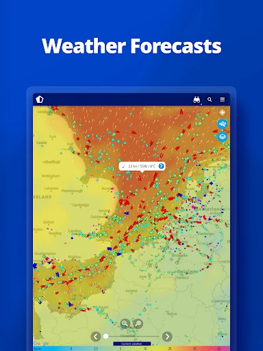
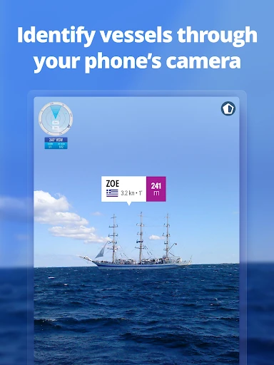
Wind information adds another useful layer. I can see live wind on the map and check a 48-hour forecast, which gives the surrounding conditions some context. The augmented reality tool offers a more immediate way to identify vessels around me: point the device camera toward the horizon and view details such as name, flag, speed, and distance. It is a distinctive option for looking from shore rather than browsing the map alone.
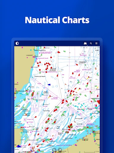
There is also a broad photo collection featuring ships, harbors, lighthouses, and more. For users who want deeper maritime data, paid subscribers can access nautical charts, advanced weather maps, advanced density maps, and satellite AIS data. Satellite tracking beyond land-based AIS range is also offered as an in-app purchase. These options make the app more flexible, but the free map remains the best place to see whether its core appeal suits me.
A relaxed harbor routine
A simple routine might start with a glance at the map before a waterfront walk. I can see which vessels are nearby, open a port to check arrivals and departures, and compare the activity with the wind information. If a ship stands out, I can search for it, add it to My Fleet, and come back later to review its track. Each step answers a slightly different question without requiring a long session.
At home, I might use the same routine to follow a vessel that is approaching a port. The estimated arrival information can help me understand its progress, while playback offers a way to look back at its route. I would keep the app’s coverage limits in mind and treat displayed details as an informative snapshot. That balance makes it a pleasant companion for maritime curiosity rather than a tool I depend on for critical decisions.
Limits to keep in view
The biggest practical limit is coverage. MarineTraffic draws on land-based AIS receivers, so the map can be more useful around major ports and shipping routes than in less-served areas. Satellite AIS can extend the view, but it is a paid option. If my interest is concentrated in one remote region, I would verify coverage there before spending money or assuming every vessel will appear.
There is also a difference between the free experience and the deeper tools aimed at paying subscribers. Nautical charts, advanced weather and density maps, and satellite AIS are not part of the same basic offering. Ads are present, too. None of that erases the value of the map and port information, but it is worth considering how much detail I actually need before choosing to pay.
Finally, MarineTraffic’s specialist focus is a strength only if I want maritime information. It will not replace a general map for everyday directions, and I would not treat vessel positions as a complete picture of what is happening at sea. For casual ship spotting and learning about port movement, those boundaries are manageable; for other tasks, a different kind of app may be a better fit.
MarineTraffic - Ship Tracking makes ship movement easier to explore, with a useful mix of vessel positions, port information, wind forecasts, playback, and photos. I especially like how it can serve both a quick look at the harbor and a longer search for a particular vessel. Its focused design gives maritime browsing a clear home.
I would recommend it to ship watchers, coastal residents, and curious users who are happy to work within AIS coverage limits. Check the area that matters to you before buying extra features, and remember that advanced tools cost extra. If you want general navigation instead, this is probably not the app to reach for.
MarineTraffic Frequently Asked Questions
What is MarineTraffic - Ship Tracking used for?
MarineTraffic displays near-real-time positions of ships and yachts on a map. You can search for vessels and seaports, check nearby activity, view port arrivals and departures, see wind information, and review a vessel’s track with animated playback. It also includes a fleet list, photos, and an augmented reality tool for identifying vessels around you.
Which devices support MarineTraffic - Ship Tracking?
MarineTraffic - Ship Tracking is an Android app available through Google Play. The listed minimum requirement is Android 7.0. For details about compatibility with a particular phone or tablet, check the Google Play listing, since device support and availability can vary.
What Android version does MarineTraffic - Ship Tracking require?
The listed minimum is Android 7.0. If you are unsure whether your device or a particular version of the app is supported, check Google Play for the current compatibility information. The app’s version can vary, so the store is also the best place to see which release is currently offered.
Is MarineTraffic - Ship Tracking free?
The app is free to download, but it contains ads and offers in-app purchases. Individual in-app products are listed from $0.99 to $94.99. Satellite tracking beyond the range of land-based AIS receivers is offered as an in-app purchase, while some advanced tools are available to paying subscribers. Check Google Play for current purchase details.
Who is MarineTraffic - Ship Tracking best for?
It is a good fit for ship watchers, people near ports, and anyone curious about vessel movements or maritime conditions. It may not suit someone looking for general directions or complete coverage in every area. Coverage depends on location, so check the region you care about before purchasing additional features.
Pros
- Combines vessel positions with useful port arrivals, departures, and estimated arrival times.
- Animated track playback and My Fleet make it easier to revisit vessels.
- Wind forecasts, photos, and augmented reality offer different ways to explore.
- The map makes maritime activity approachable for casual ship watchers.
Cons
- AIS coverage varies by location, particularly away from major ports and routes.
- Satellite tracking and several advanced tools require payment or a subscription.
- Ads and a specialist focus may not suit every casual map user.
- Category
- Maps & Navigation
- Version
- VARY