DC Metro & Bus: WMATA Realtime
- 7.29K
- 2.8
- Installs
- 500.00K
- Price
- Free

Screenshots
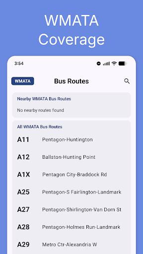

Analysis by Reviewed APKs
DC Metro & Bus: WMATA Realtime is a Washington-area transit companion for checking Metro train and bus arrivals, planning trips, and finding stops on an interactive map. I found its focus on the local network more useful than a broad travel app when I wanted a quick answer about a familiar commute. It is practical for regular riders and visitors alike, though its regional focus and advertising may not suit everyone.
A Commute, Checked in Seconds
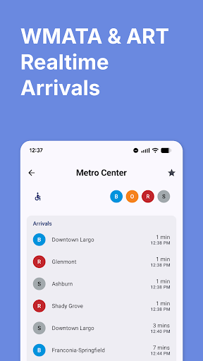
When I first used DC Metro & Bus: WMATA Realtime, I pictured an ordinary weekday: walking toward a station, wondering whether to hurry, and wanting a useful arrival estimate before reaching the platform. The app puts real-time rail predictions and bus arrivals at the center of the experience. I could look up a station or stop and check the next vehicle, rather than relying only on a printed timetable or trying to remember a schedule.
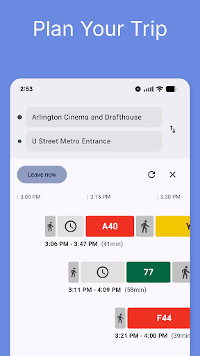
The same routine works when a trip involves more than one ride. I could enter a starting point and destination in the trip planner and get step-by-step directions that use Metrorail, Metrobus, and Arlington Transit. For someone visiting DC, that means having a way to think through a route before setting off. For a regular rider, it is a handy check when plans change or a familiar journey needs a different connection.
A Regional Specialist
This app is built around the Washington, DC, Maryland, and Northern Virginia transit network, rather than trying to serve transit riders in every city. That local focus shows up in its search, which covers Metrorail stations, Metrobus routes, ART stops, and DC Circulator lines. If my main question is about getting around the DMV, having those local services in one place feels more direct than starting with a general-purpose map.
It is a transit information and trip-planning tool, not a replacement for every part of a travel day. The supplied details cover arrivals, route planning, maps, favorites, and elevator or escalator status; they do not describe fare purchases or a fare calculator. The app also requires network access to use its resources, so I would not treat it as a dependable offline guide. Its usefulness is greatest when the trip stays within its covered area.
Make Repeat Trips Easier
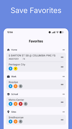
A small habit that makes this kind of app more useful is saving the stops I check most often. DC Metro & Bus lets riders keep favorite stations and stops for one-tap access, so a home station or a bus stop near work does not need to be searched from scratch each time. I would set those up around my regular routine, then use the arrival screen as a quick check before leaving.
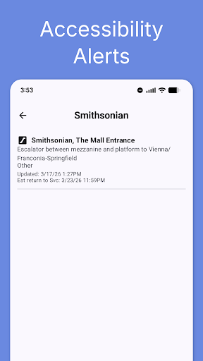
For an unfamiliar journey, I would combine the planner and map rather than treating them as separate tools. Search for a destination, review the suggested directions, and use the interactive map to get a wider sense of the rail lines and nearby stations. Before a station trip, checking elevator and escalator status is another practical step, especially when accessibility or avoiding a broken escalator matters. These checks help me make a more informed plan without adding much effort.
More From Our News Desk

Zoom Meetings, Google Meet, or Teams: Which Is Easiest to Join?

How I Build a Free Streaming Lineup With Tubi

Why Crunchyroll Is the Default Anime App for So Many Fans

YouTube TV: A Practical Guide to Cutting Cable

Rummikub and the Small Comfort of Phone Games
TeamViewer Remote Control or AnyDesk for Helping Family?
Who May Find It Useful
I would recommend DC Metro & Bus: WMATA Realtime to people who regularly use Metrorail or Metrobus in Washington, DC, Maryland, or Northern Virginia. Its live arrival information, local trip planning, searchable network, and saved stops are a sensible combination for a commute that repeats through the week. Visitors can also use it to explore the system and plan a ride, while Arlington Transit coverage adds another useful local option.
It may be a weaker fit for someone who wants a transit app for many different cities, needs offline information, or expects fare purchasing and fare calculations in the app. Ads are part of the experience, and Google Play shows a 2.8-star rating from about 7,300 ratings, so I would approach it with realistic expectations. Riders who mainly need local arrival checks may still find its focused tools worthwhile.
DC Metro & Bus: WMATA Realtime is a free Android app from Dixon Mobility, LLC in the Maps & Navigation category. Google Play shows over 500,000 installs and a 2.8-star rating from 7,292 ratings. The app contains ads and offers in-app purchases, with listed items priced from $1.99 to $23.99. Its content rating is Everyone.
The current version in the supplied app facts is 4.0.62. Those facts give an original release date of October 20, 2012, and a last update date of April 27, 2026. The minimum Android version is not included in the available details, so check Google Play for the requirement on your device. The description says the app is free to download and use, with an optional ad-free upgrade.
A Closer Look at Daily Transit
First Look and Setup
My first impression is that this app has a clear job: put DC-area transit information within quick reach. It is not trying to be a general travel planner for every kind of trip. Its main tools revolve around the local rail and bus network, including live arrival information, trip planning, station search, and an interactive system map. That tight scope makes sense for someone whose everyday journeys mostly happen in the DMV.
Getting value from it starts with having network access, because the app's resources require a connection. After opening it, I would begin with a familiar station or bus stop to see how arrival checks fit my routine, then save the stops I use most. The description also calls out a modern Material 3 interface designed for one-handed use, a helpful consideration when checking information while walking or waiting.
The Everyday Check
The core experience is looking up the next train or bus without having to interpret a static schedule. The app provides real-time rail predictions for Metrorail stations and bus arrivals for Metrobus stops. I can see why that is useful in the small gaps of a commute: while heading out the door, standing near a stop, or deciding whether I have time to make a connection.
The trip planner extends that quick check into a fuller journey. I can provide a start and destination and get directions using Metrorail, Metrobus, and Arlington Transit. That makes the app more than an arrival board, especially for a visitor or a rider whose usual route is disrupted by a change in plans. The practical value is having both immediate timing and a way to think through the route.
Local Tools That Stand Out
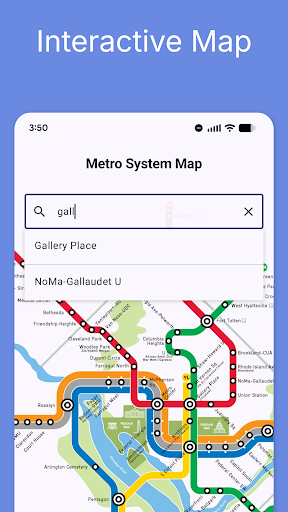
The interactive WMATA map is a useful complement to text directions. Riders can zoom around the system, search for a station by name, see rail lines together, and tap a station to check real-time arrivals. I like that sequence because it connects the broader question—where does this line go?—with the immediate one: when is the next train? It can help make an unfamiliar part of the rail network feel easier to read.
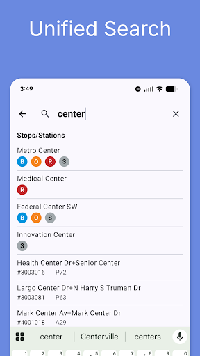
Search spans Metrorail stations, Metrobus routes, ART stops, and DC Circulator lines from one search bar. Favorites offer another small but meaningful convenience, keeping common stops close at hand. Elevator and escalator status is also included for stations, which can help riders check access conditions before travelling or simply avoid an out-of-service escalator. These are specific local details rather than generic extras.
A Useful Planning Routine
For a regular commute, I would make favorites the starting point: save the station I leave from and the bus stop I use most. Before heading out, check the relevant arrival estimate, then open the planner if I need a different route that day. That keeps the repeated task quick while leaving room to reconsider the journey when my normal pattern no longer fits.
For a day exploring DC, I would start with the destination and use the planner to see how Metrorail, Metrobus, or ART can get me there. The map can then provide a broader view of stations and lines, while a station tap brings arrival information into the same flow. If accessibility or escalator status matters for that station, I would check its listed elevator and escalator information before setting off.
Limits to Keep in Mind
The regional focus is both a strength and a boundary. This is designed for Washington-area transit, so it is not the app I would choose for a trip in another city. Its listed coverage includes Metrorail, Metrobus, Arlington Transit, and DC Circulator search, but the trip-planning directions specifically mention Metrorail, Metrobus, and ART. Riders should keep those distinctions in mind when planning.
The app needs network access to use its resources, which matters when connectivity is unreliable. It also contains ads, and in-app purchases are available. The Google Play rating is 2.8 stars, a figure worth weighing alongside the feature set rather than overlooking. Finally, the supplied description identifies the app as independent of WMATA, ART, and government entities, so I would view it as a third-party way to access transit information.
DC Metro & Bus: WMATA Realtime brings together the everyday tools I would want for local transit: arrivals, trip planning, a map, search, favorites, and station accessibility status. Its focused coverage makes it more appealing to DMV riders than to people looking for an all-purpose travel app. The ads, network requirement, and modest Play rating are real considerations.
I would try it if I regularly travel around Washington, DC, Maryland, or Northern Virginia and want a dedicated place to check WMATA-area journeys. Visitors may also appreciate having local routes and arrivals together. If I needed offline access, broad city coverage, or fare tools, I would look elsewhere or check the available options before relying on it.
DC Metro & Bus Frequently Asked Questions
What is DC Metro & Bus: WMATA Realtime used for?
DC Metro & Bus: WMATA Realtime helps riders check Metrorail train predictions and Metrobus arrivals, plan trips, search local transit stops and routes, and explore an interactive system map. It also includes favorites and station elevator and escalator status. Its coverage is centered on the Washington, DC, Maryland, and Northern Virginia area.
Which devices and platforms support DC Metro & Bus?
The supplied app information identifies DC Metro & Bus: WMATA Realtime as an Android app available through Google Play. It requires network access to use its resources. Check the Google Play page for device compatibility and the Android version requirement that applies to your device, since that requirement can vary.
What Android version does DC Metro & Bus require?
The minimum Android version is not provided in the available app facts. Before installing, check the Google Play page for the current requirement and compatibility with your device. The app's version in the supplied facts is 4.0.62, but that does not by itself establish which Android versions can run it.
Is DC Metro & Bus free, and does it have purchases?
DC Metro & Bus: WMATA Realtime is free to download and use, and its description mentions an optional ad-free upgrade. Google Play facts indicate that the app contains ads and offers in-app purchases priced from $1.99 to $23.99 per item. Check Google Play for current purchase details, since available items and pricing may vary.
Who should use DC Metro & Bus: WMATA Realtime?
It is best suited to people who ride Metrorail, Metrobus, or covered local services around Washington, DC, Maryland, and Northern Virginia. Visitors may also use its planner and map to explore the area. It may not suit riders seeking an offline tool or a transit guide for cities outside its regional focus.
Pros
- Combines local train and bus arrival checks with trip planning and an interactive map.
- Search covers Metrorail, Metrobus, ART stops, and DC Circulator lines.
- Favorites make frequently used stations and stops quicker to reach.
- Station elevator and escalator status can help riders plan ahead.
Cons
- Requires network access to use its transit resources.
- Contains ads, with optional in-app purchases available.
- Its regional focus does not serve transit journeys in other cities.
- Category
- Maps & Navigation
- Version
- 4.0.62