My Elevation
- 25.87K
- 4.8
- Installs
- 1.00M
- Price
- Free
Screenshots
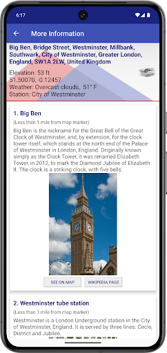
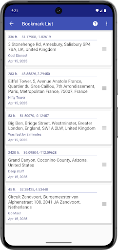
Analysis by Reviewed APKs
My Elevation is a location and map app for checking the surface elevation of your current position or a place anywhere in the world. It also lets you explore weather, nearby Wikipedia articles, bookmarks, and map display options. I find its combination of a practical elevation readout and casual place discovery appealing, especially for people who like to understand the terrain around them. Just remember that it needs a working data connection.
Checking a Route as You Go
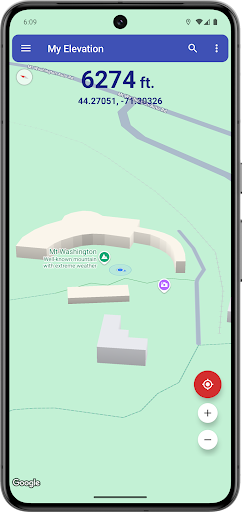
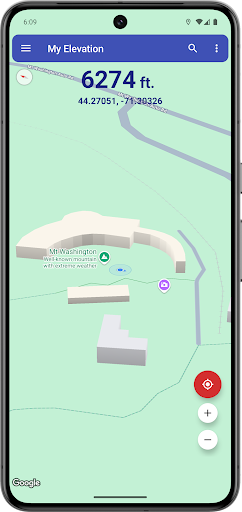
Imagine setting out for a walk and wondering whether the route ahead climbs steadily or levels off. With Follow Me mode, My Elevation follows your current location on a map and updates your elevation and coordinates as you move. I like that this gives the readout a real-world context: rather than seeing a number in isolation, I can watch where I am on the map as the journey unfolds.
The app is aimed at surface elevation above sea level, based on your location, rather than altitude in every possible situation. So it is useful for curiosity about the ground beneath you, or for following a walk, but it is not a way to measure how high you are in an aircraft or inside a tall building. It also relies on a working data connection, so it is best used where the map and web services can load.
More Than a Height Readout
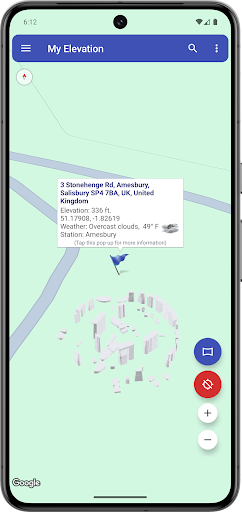
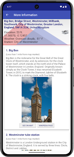
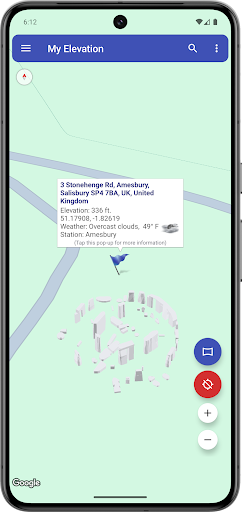
A basic map app is usually enough when all I need is to see where a street goes. My Elevation has a more specific starting point: it puts surface elevation and coordinates alongside a map, then adds ways to explore a selected location. Searching for a place or long-pressing the map can bring up its weather and nearby Wikipedia articles, making the app useful for browsing as well as checking a number.
That extra material makes it a handy companion for looking around, but it is not a full navigation or offline mapping tool. The app description does not promise offline access, and it explicitly requires data to show your position and retrieve elevation and other content. I would choose it for elevation curiosity and lightweight place exploration, not as a replacement for a dedicated route planner or a source of in-flight altitude.
Small Habits That Help
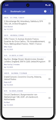
When I want to compare a few places, I would search for each one or long-press its spot on the map, then use the elevation and weather information to get a quick sense of the area. Saving a bookmark for a place I want to revisit keeps that discovery from becoming a one-off. Sharing a location or search result by text or email is another straightforward way to pass along something interesting.
I would also take a moment to choose the map style that suits the question. Normal, Satellite, Topo, and Hybrid are available, along with heading-up, map tilt, and night mode options. Topo is a natural choice when terrain is the point; Satellite or Hybrid can give a different visual perspective. These settings do not change the app’s reliance on data, so I would check connectivity before heading somewhere remote.
More From Our News Desk

Zoom Meetings, Google Meet, or Teams: Which Is Easiest to Join?

How I Build a Free Streaming Lineup With Tubi

Why Crunchyroll Is the Default Anime App for So Many Fans

YouTube TV: A Practical Guide to Cutting Cable

Rummikub and the Small Comfort of Phone Games
TeamViewer Remote Control or AnyDesk for Helping Family?
Who Might Enjoy It
I would recommend My Elevation to people who often look at maps with a question in mind: how high is this place, what is nearby, or what does the surrounding terrain look like? Walkers, travelers, and curious map browsers can make use of its location following, search, bookmarks, and weather and Wikipedia links. It is also approachable for someone who wants a quick elevation check without turning the task into a larger mapping project.
It may not suit someone who needs offline map access, altitude while flying, or a dedicated navigation tool. The app needs a working data connection for its map position, elevation, and additional content, which matters when planning to use it away from coverage. I would also skip it if all I want is a simple map with no extra information. Its strengths are most apparent when I want to explore a location, not just get from one place to another.
My Elevation is an Android Travel & Local app from RDH Software. On Google Play it has over one million installs and a 4.8-star rating from around 25,900 ratings. It is free to download and contains ads, with no in-app purchases. The content rating is Everyone. The app was released on January 28, 2014, and its current version is 1.93.009.
The recorded last update is October 22, 2026. My Elevation uses web services and requires a working data connection for its map position, precise surface elevation, and additional content; it has no offline mode. A minimum Android version is not included in the available app facts, so anyone checking device compatibility should look at the current Google Play information.
A Closer Look at My Elevation
A Map-First Start
When I first open an app about elevation, I want to know where the number comes from. My Elevation grounds the result in a latitude and longitude, using web services to provide surface elevation for a location. That map-based approach makes the idea easy to grasp: the reading belongs to a point on the ground, rather than being an abstract figure without a place attached.
The first practical thing to keep in mind is connectivity. The app needs a working data connection to show your position on the map and retrieve elevation and other content. I would open it before a trip or walk where coverage may be unreliable, rather than expecting it to become a useful offline map. That requirement shapes the experience from the start.
Following a Place
Follow Me mode is the feature I would use when moving around. It keeps the map centered on the idea of my current position and updates the displayed elevation and coordinates as I travel. On an ordinary walk, that turns a quick check into something I can revisit along the way, especially if I am curious about how the ground changes between one point and the next.
For a place I am not currently standing in, search provides another route in. The map can move to the selected location, while a long press lets me choose a point directly. Both approaches connect the map interaction with local weather and nearby Wikipedia articles. That makes browsing a place feel more informative than simply dropping a pin and moving on.
Useful Extra Layers
The range of map display options is a welcome bit of flexibility. I can choose Normal, Satellite, Topo, or Hybrid, then use heading-up, map tilt, or night mode to adjust the view. I would reach for Topo when I am thinking about terrain and switch to Satellite or Hybrid when I want another perspective on the surroundings. These are viewing choices, not a substitute for connectivity.
Bookmarks help keep interesting locations within reach, while sharing lets me send my current location or something I found in a search by text or email. I can see these being useful for a saved destination I want to look at again or a place I want to show someone. They complement the map and elevation tools without changing the app’s basic purpose.
A Simple Exploring Routine
For a low-key planning session, I would search for a destination and check its elevation, then look at the weather and browse nearby Wikipedia articles. If a location seems worth returning to, I would bookmark it. I could compare the view in Topo and Satellite mode before sharing the spot with a friend. It is a small routine, but it gives the app several ways to help me understand a place.
On a walk, I would use Follow Me mode when I want to see my position and changing elevation together. If I noticed a point worth checking, I could long-press the map and explore its details. This works best as an occasional check-in rather than a promise of uninterrupted information: My Elevation depends on a working data connection to provide its map position and online content.
Know What It Measures
The key distinction is between surface elevation and altitude. My Elevation reports the elevation above sea level of a point identified by latitude and longitude. It does not provide altitude when someone is in an aircraft, high inside a building, or otherwise far above the ground. That makes the app’s intended measurement clear, but it also means the number should not be treated as a readout for every kind of height.
The other practical limit is its online dependence. There is no offline mode, and the app needs data for the map, precise elevation, and additional content. I would not count on it in a location without service. Those limits do not undermine its use for connected map exploration, but they are important when deciding whether it fits a particular trip or question.
My Elevation is a focused but pleasantly exploratory map app. It combines current-location elevation and coordinates with location search, weather, nearby Wikipedia articles, bookmarks, sharing, and several map views. I like that it can answer a quick terrain question and then give me a reason to look around a little longer.
I would recommend it to curious travelers and walkers who have a data connection and want to explore surface elevation alongside a map. It is less suitable for offline use, navigation, or checking altitude away from the ground. If those boundaries match what you need, My Elevation offers a useful set of location tools in one place.
My Elevation Frequently Asked Questions
What is My Elevation used for?
My Elevation shows surface elevation above sea level for a location based on its latitude and longitude. It can follow your current position, search for places, and show weather and nearby Wikipedia articles. You can also bookmark locations, share a location or search result, and choose among several map display options. It does not provide altitude for situations such as being in an aircraft or high inside a building.
Which devices can run My Elevation?
My Elevation is an Android app available through Google Play. A minimum Android version is not included in the app facts, so compatibility can depend on your device and may be worth checking on the current Google Play page. The app needs a working data connection for its map position, elevation information, and additional content.
Does My Elevation cost money?
My Elevation is free to download and contains ads. The app facts say it does not offer in-app purchases. Store details can change over time, so it is sensible to check the current Google Play page for the latest information before installing.
Does My Elevation work without internet?
No. My Elevation requires a working data connection to show your position on the map, retrieve precise elevation, and provide its additional content. It does not have an offline mode. If you expect to use it somewhere with unreliable coverage, that limitation is worth considering before you rely on it.
Who is My Elevation best suited for?
It is a good fit for people who like checking surface elevation and exploring locations on a map, including travelers and walkers who have a data connection. Its search, bookmarks, weather, nearby Wikipedia articles, and map styles support casual place discovery. It may not suit people looking for offline maps, navigation, or altitude readings while above the ground.
Pros
- Combines surface elevation and coordinates with a map-based view.
- Search and long-press both help explore places beyond your current location.
- Includes bookmarks, sharing, weather, nearby Wikipedia articles, and multiple map styles.
- Follow Me mode updates location and elevation while you move.
Cons
- Requires a working data connection and has no offline mode.
- Measures surface elevation, not altitude while high above the ground.
- Contains ads, even though it is free to download.
- Category
- Travel & Local
- Version
- 1.93.009