Fishing Spots: Fish Maps
- 6.92K
- 4.4
- Installs
- 1.00M
- Price
- Free
Screenshots
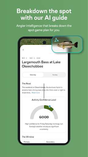
Analysis by Reviewed APKs
Fishing Spots: Fish Maps brings fishing maps, forecasts, tide information, and catch records into one Android app. I can see it suiting anglers who like to plan a day on the water and keep notes about what happened, whether they fish lakes, rivers, or coastal areas. After looking at its mix of practical tools and community features, my overall take is that it offers a useful planning hub, with plenty to explore before a first cast.
Planning a Day on the Water
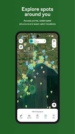
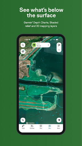
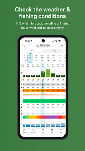
When I picture using Fishing Spots: Fish Maps, it’s the evening before a weekend outing. I’d open the map around a familiar lake, look over its depth information and contours, and check for access points or boat ramps. Then I could compare the fishing forecast with the weather, wind, and solunar timing before deciding when to leave. It brings several pieces of trip planning together instead of making me jump between unrelated tools.
The useful part is how a plan can continue after the trip starts. Tide charts and weather details can help me think through changing conditions, while maps show different kinds of water and underwater structure. Afterward, a catch log gives me a place to record the outing and look back at what I caught. That makes the app feel less like a one-time spot finder and more like a companion for planning and remembering fishing trips.
More Than a Basic Map
A regular map app can help me reach a lake or find a road nearby, but Fishing Spots: Fish Maps is organized around fishing decisions. Its maps include depth charts and contours, and the app also brings in forecasts, tides, moon phases, and catch logging. That broader focus is handy when I want to compare a location with conditions and keep notes, rather than simply get directions to a place.
I wouldn’t treat it as a replacement for time on the water or as a promise that a spot will produce fish. It’s a planning and record-keeping tool, not a substitute for local judgment. Anglers who mainly want a simple navigation app may find the extra fishing information unnecessary. Those who enjoy checking conditions, exploring different waters, and tracking their own outings are more likely to appreciate its wider scope.
Build a Useful Fishing Record
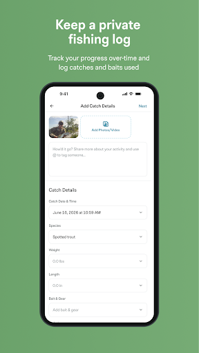
A small habit that could make the app more valuable is logging a catch soon after it happens, while the details are still fresh. The description says the log can track catches and support analysis of past results, including the baits, lures, and conditions that worked. A few consistent notes over time would be more useful than trying to reconstruct a whole season from memory.
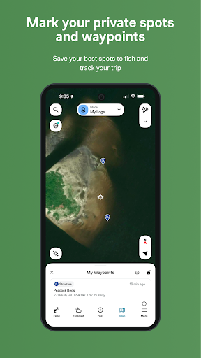
I’d also make trip planning a short routine rather than a deep research session. Check the map and access points first, then review weather, tides, or river conditions that apply to the water I’m visiting. Saving private waypoints for favorite places can help keep personal locations organized. The point is to use the app as a steady notebook and planning aid, not to chase every forecast detail.
More From Our News Desk

Zoom Meetings, Google Meet, or Teams: Which Is Easiest to Join?

How I Build a Free Streaming Lineup With Tubi

Why Crunchyroll Is the Default Anime App for So Many Fans

YouTube TV: A Practical Guide to Cutting Cable

Rummikub and the Small Comfort of Phone Games
TeamViewer Remote Control or AnyDesk for Helping Family?
Who Might Enjoy It
I’d recommend Fishing Spots: Fish Maps to anglers who like to prepare before heading out and reflect on what worked afterward. It covers a broad range of fishing settings, from lakes and rivers to coastal waters, and combines mapping with forecasts, tide information, and a catch log. Beginners may find the collection of tools useful for learning what details to consider, while experienced anglers can use it to organize their own observations.
It may be less appealing to someone who wants only a bare-bones map or who rarely records trips. The breadth of information can take time to explore, and some features are tied to VIP access. If you prefer to keep fishing plans entirely offline or don’t want ads in a free app, those points are worth considering. The app is best suited to people who enjoy using digital tools alongside their own experience.
Fishing Spots: Fish Maps is developed by FishAngler, LLC and is available on Google Play for Android. It has more than one million installs and a 4.4-star rating from about 6,900 ratings. The app is free to download, contains ads, and offers in-app purchases. Google Play gives it a Teen content rating.
The current version is 5.3.1.228. The app was released on February 2, 2018, and its last update is dated October 27, 2026. In-app purchases range from $6.99 to $49.99 per item. VIP is described as unlocking premium mapping and forecast features; the free download includes the app’s broader fishing toolkit.
A Closer Look at the Fishing Toolkit
Opening the App
When I first opened Fishing Spots: Fish Maps, the range of tools stood out more than any single feature. Maps, conditions, tides, catch records, and community information all belong to the same fishing-focused product. That makes the app sound especially useful for someone who plans trips in advance, though it also means there is more to explore than there would be in a simple location finder.
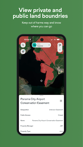
I’d start by focusing on the water I know best, rather than trying to understand every map layer at once. The description covers lake maps, depth charts, satellite views, nautical charts, and access points. Starting with one familiar area gives me a practical way to see how the map information fits together and which details I actually use when planning.
Checking Conditions Day to Day
The everyday appeal is having several conditions in one place. Fishing Spots: Fish Maps describes local weather, wind speed, air pressure, water temperature, animated radar, river flow, and gauge height, alongside tide charts and solunar timing. Not every outing calls for checking every item, but having a range of context can help me think through whether a plan needs adjusting.
I’d use those details as reference points, not as a rigid schedule. Conditions can change, and a forecast is only one part of deciding where and when to fish. The app’s combination of forecast and map information is a sensible convenience, especially when planning around water that I don’t visit every week.
Maps and Catch Records
The mapping features are a central strength on paper. The app describes depth charts and contour lines, satellite maps, nautical charts, and information on boat ramps and fishing access. Filters can help narrow locations by species, water depth, or underwater structure. For someone exploring a new lake or coastal area, that range makes map browsing more purposeful than simply scanning for water.
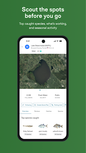
The catch log adds a different kind of value. Rather than only helping me decide where to go next, it gives me a way to keep a record of outings and catches. The description also mentions AI fish identification and personalized insights. Those features may appeal to anglers who enjoy documenting trips, while the private waypoint option is useful for organizing favorite locations discreetly.
A Repeatable Trip Routine
A practical routine might begin the night before: check the map for access and structure, review the forecast and any relevant tide or river information, then settle on a general plan. On the day, I could revisit conditions before leaving and use the available map layers to orient myself. This keeps the preparation focused on a few decisions rather than turning it into an endless search.
After fishing, I’d add a catch or trip note while I still remember the details. Over time, the log could help me compare outings and see which baits or conditions have been associated with catches. I’d keep the entries simple enough to maintain consistently. A useful record is one I’m willing to keep updating, not a complicated journal that becomes another chore.
Keep Expectations Grounded
The app offers a lot of information, but more data doesn’t automatically make a fishing trip better. Maps and forecasts can inform a plan; they can’t account for every local change or replace experience. I’d treat catch reports and community tips as additional perspectives, not as instructions that will apply equally to every angler or every day.
There are also practical trade-offs. The free app contains ads, and VIP features are available through in-app purchases. People who only want a quick map may not need the extra tools, while those who enjoy detailed planning may need time to find a comfortable routine. Keeping expectations modest makes the app’s role clearer: it can help organize decisions and records, but fishing remains unpredictable.
Fishing Spots: Fish Maps makes the most sense as a fishing-focused planning and logbook app. I like the combination of maps, conditions, and catch records, especially for anglers who want their trip preparation and notes in one place. Its broad feature set is appealing, provided you’re comfortable spending a little time finding the tools that matter to you.
I’d suggest trying it if you fish regularly and enjoy reviewing conditions or keeping a record of your catches. If all you need is a simple map, it may be more app than you want. For curious, organized anglers, it’s a capable collection of fishing resources, with paid VIP options and ads to keep in mind.
Fishing Spots Frequently Asked Questions
What is Fishing Spots: Fish Maps used for?
Fishing Spots: Fish Maps helps anglers explore fishing locations and plan outings with maps, depth and contour information, forecasts, tides, and weather details. It also includes a catch log, private waypoints, and community reports. I’d think of it as a planning and record-keeping companion, rather than a tool that can predict exactly where fish will bite.
Which devices support Fishing Spots: Fish Maps?
Fishing Spots: Fish Maps is an Android app distributed through Google Play. The supplied information doesn’t specify a minimum Android version, so check the Google Play store page on your device for current compatibility details. That’s the best place to confirm whether your particular phone or tablet can install it.
How much does Fishing Spots: Fish Maps cost?
The app is free to download and contains ads. It offers in-app purchases priced from $6.99 to $49.99 per item, and its description says VIP unlocks features such as premium depth charts, 3D lake maps, extended forecasts, and custom map modes. Purchase options can change, so check Google Play for current details.
Does Fishing Spots: Fish Maps need a particular Android version?
The minimum Android version isn’t included in the available app details. Because compatibility requirements can vary as the app is updated, check Fishing Spots: Fish Maps on Google Play from the device you plan to use. Google Play will show whether that device meets the current installation requirements.
Is Fishing Spots: Fish Maps a good fit for beginners?
It can suit beginners who want to explore maps, forecasts, tides, and catch logging in one place, as well as experienced anglers who like keeping trip records. Its collection of tools may feel like more than necessary if you only want simple directions. The free app contains ads, and some features are part of VIP.
Pros
- Combines fishing maps, forecasts, tide information, and catch logging in one app.
- Offers map details including depth charts, contours, access points, and nautical views.
- Catch records and private waypoints can help organize ongoing fishing routines.
- Includes weather, river conditions, and community reports for trip planning.
Cons
- The range of tools may feel excessive for anglers who only need a basic map.
- The free version contains ads, and some features require in-app purchases.
- Forecasts and reports can inform a plan but cannot remove fishing’s uncertainty.
- Category
- Sports
- Version
- 5.3.1.228